This is a lot like the articles I was all up ons a while ago from Europe. There were various studies and traffic control designers that found car drivers would slow down if the environment felt like slower speeds were required. And the best way to convey that is not with a speed limit sign, but with other visual cues. In one study, they found removing all lane lines and signals worked best. Hang on, let me see if I can find that mess...
Yeah, that's exactly what I'm talking about. September 2006. If you didn't read it, go ahead and take a minute; I'll wait. Yeah? Good stuff right? Well it really hit home when I read this article in GGW about Conn ave. I commuted up and down that road for a year, so I can personally attest that its a six lane highway out of the city that happens to run through a certain moneyed neighborhood. Now, I understand that Chevy Chase doesn't want high velocity traffic running right through the middle of it, but maybe they should design a road that feels like the speed limit is 30, instead of slapping a lower limit on a faster road and sending tickets to every car that drives down it.
Traffic slows just south of Chevy Chase Circle (in DC) because there are cross streets, shopping centers and pedestrians. That seems like a much more effective control measure than white signs and speed cameras disguised as trashcans. Unless your real goal is benjamins, not safely.
Showing posts with label traffic. Show all posts
Showing posts with label traffic. Show all posts
Tuesday, February 17, 2009

Wednesday, November 19, 2008
The Ants Screw Me Again.
Okay, so I've got a bit of history with ants. Honestly, these dudes are annoying, right? Well some kinda researchers think that ants may be the solution to some of our traffic congestion woes.
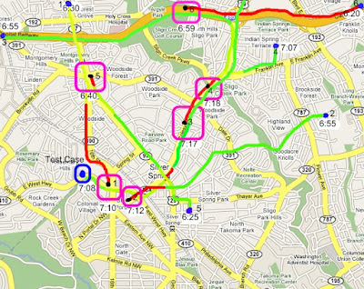
Seems like it'd make sense, right? Individuals who've just traveled on a path can communicate with those headed the opposite direction into the observed conditions. Oddly enough this eerily reminds me of an idea I postmarked on 2/21/07. Take a look:
Freaking ants stole my idea and sold it to some German Scientists! And you call me crazy when I rant about ladybugs trying to kill me and not being able to trust insects.
When the narrow route, as expected, became congested, ants know to tell each other to redirect their travels. An ant returning from the congested narrow route encounters another ant heading up that route and pushes that ant towards the wider lane.
Seems like it'd make sense, right? Individuals who've just traveled on a path can communicate with those headed the opposite direction into the observed conditions. Oddly enough this eerily reminds me of an idea I postmarked on 2/21/07. Take a look:
Wireless Real-time Itinerant Social Traffic System
A mobile system that uses social information, made publicly available, to
compile useful individual results for a single entity of the entire
social group.
The system would harvest speed, congestion and general flow
information from a vehicle's on-board sensors and create a recent
database track with geographic locations, times and infrastructure
conditions. No optical or radio traffic monitoring equipment (to gather data on opposing cars
without WRISTS installed) is required, but may enhance the overall
community performance if present. As the vehicle proceeds on its route
it actively searches with a wireless connection for oncoming vehicles
also equipped with a compatible system.
When a peer is found the systems trade recent databases,
merging current road condition information. Each vehicle now possesses
a complete local traffic map of the area with reliability ratings pertaining to data recency and surety of diagnosis. (some traffic
patterns are easier to diagnose) Vehicles may also choose to rate
personally collected data higher, or flag data, so that inconsistencies
can be leveled out of the network should errors arise.
The in-vehicle system will then use this information in its on
screen navigation, creating alternate routes to minimize travel time
(or another variable at the users discretion) to way-points in the
infrastructure. The information may be displayed on the navigation
screen by classifying roads into color groups, or may be used silently
by the system to reroute traffic.
Systems will need to be self tuning, calibrating for how long
data may be used before it is no longer representative and must be
discarded. In some areas 2 hours and 100 miles of data may be useful,
while in other areas 15 minutes and 4 miles is the maximum lifespan.
The system will also learn tendencies of specific roads over
time for personal use, should a user frequent a particular area. This
will allow for general prediction of traffic
flows in routing. So if a thoroughfare is clear at 7:30, but is
usually full at 8:10, the system can compute ETA to the hot spot and
smartly disregard "road clear" information that it calculates likely to
be out of date on arrival. This average road condition prediction is
not for social use, only recently harvested information is transmitted
throughout the network. In addition existing traffic broadcast systems or fixed traffic
counters may be integrated into routing because they mark known
accidents and closures, but this information is for personal use, not
socially distributed. This is intended to maintain the purity of the
network so that only fresh and near-firsthand information is used which
will eventually result in better local response times than widely
aggregated reports of a metropolitan area.
With multiple users an entire area of main thoroughfares can be mapped fairly quickly, depending on traffic speed and transmission range. The more users there are, the more current and ubiquitous the data will be.When enough users are enabled, oncoming traffic will act as a conduit for road information to stopped traffic. For example(figure 2): A car (A) in a traffic
jam can pass information to car (B) as it proceeds in the opposite
direction. Car (B) will in turn pass information to car (C) which is
pointed the same direction as car (A) and in the same traffic jam. Car (C) can then use information passed backwards down the traffic jam to decide whether to reroute or to wait for traffic to clear.
In more advanced situations cars with similar repeated tracks may suggest "bond" may also communicate destination way-points.
To
study: minimum number of devices for system to function. Effect of
congestion avoidance on quality of data, multiple concurrent reroutes.
Make extrapolated congestion based on routes and reported trends
public? (figure1: assume traffic is red between 7:12 and 7:17 links)

Freaking ants stole my idea and sold it to some German Scientists! And you call me crazy when I rant about ladybugs trying to kill me and not being able to trust insects.
Tuesday, November 04, 2008
Holy Moses.
Well, I dropped by my polling place this morning. Wow. That's quite a few people that'd like to cast a ballot. The red line below represents the salivating public about to get its vote on. Actually it wasn't a big deal at all to see since the poll is literally connected to my building. My plan was to head down and see if there was a long wait and head to work if there was. But I really didn't expect anything like this. There were people stacked up out the front of the NOAA building, through the green space, down the sidewalk, under the drive-up portico, down the length of my building and around the back. Adding insult to injury, the line did not appear to be moving in the slightest.
It can't be this bad all day, so I hopped back in the elevator and went down to the parking deck to get my car. The voters scuttled out of the way as I exited and proceeded to work. So the new plan is to call the concierge desk and ask how long the line is after everyone's lunch hour is over. I just can't rationalize standing in a line that long when I work 15 minutes away, have someone who can tell me if there's a line and live in a building that touches the poll.
Who knows maybe I'll end up standing in that line at 8:00 tonight because it doesn't get any shorter. But I doubt it.
Actually it wasn't a big deal at all to see since the poll is literally connected to my building. My plan was to head down and see if there was a long wait and head to work if there was. But I really didn't expect anything like this. There were people stacked up out the front of the NOAA building, through the green space, down the sidewalk, under the drive-up portico, down the length of my building and around the back. Adding insult to injury, the line did not appear to be moving in the slightest.It can't be this bad all day, so I hopped back in the elevator and went down to the parking deck to get my car. The voters scuttled out of the way as I exited and proceeded to work. So the new plan is to call the concierge desk and ask how long the line is after everyone's lunch hour is over. I just can't rationalize standing in a line that long when I work 15 minutes away, have someone who can tell me if there's a line and live in a building that touches the poll.
Who knows maybe I'll end up standing in that line at 8:00 tonight because it doesn't get any shorter. But I doubt it.
Update:
 Yeah, uhh... so at 3:13 there's absolutely no line at my polling place. I heard that a friend stood in that line for three hours this morning. Ouch. It took me just about 6 minutes to tally my vote, including the walk from my lobby. I also thoroughly enjoy that my front door is closer to the polls than electioneering materials. At least I didn't see any.
Thursday, August 16, 2007
A Finely Choreographed Brain Hemorrhage.
 Holy Bejezus. What in the world was going on here that you decided to create the traffic control equivalent of a black hole? My brain is swelling up just trying to figure out what is sposed to happen in this thing. But that may be because everyone is driving on the wrong side of the road. Be warned, spend too much time thinking about this and your brain may explode. I have no idea what would happen if I came across one of these in a car. I guess I'll just avoid Swindon like the traffic circle plague.
Subscribe to:
Posts (Atom)